Smarter Traffic, Safer Roads: How AI Robocopters Unlock Real-Time Mobility Intelligence
The congestion problem needs an aerial answer
Cities are under pressure. Traffic volumes keep climbing, incidents cascade into gridlock, and fixed roadside sensors miss what’s happening a few streets away. Human patrols can’t be everywhere at once, and by the time a problem is spotted, queues are already forming. Transport authorities and city planners need a way to see the whole network at once, respond without delay, and learn from patterns that aren’t obvious at ground level.
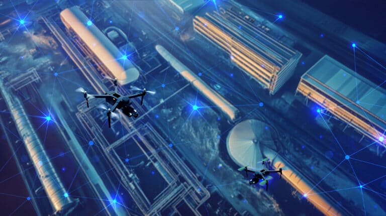
That’s why Rumble Tools built Skyfleet: a network of autonomous, AI-powered robocopters that delivers continuous, wide-area traffic monitoring and rapid incident response. Think of it as a living, breathing aerial layer over your roads, motorways, junctions, and construction corridors—always on, always learning, always ready.
From blind spots to full-spectrum visibility
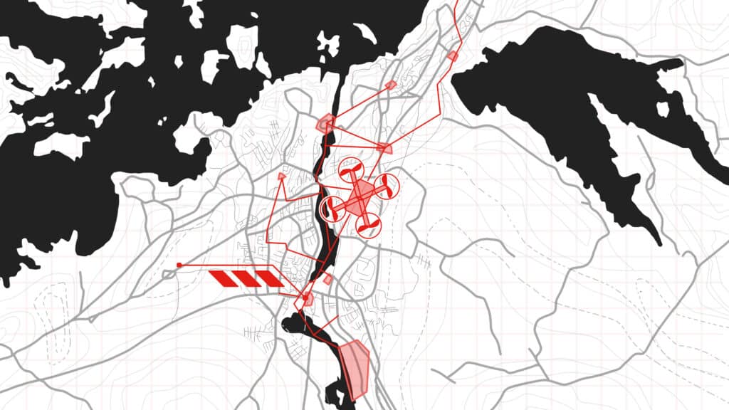
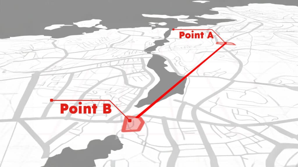
Traditional systems rely on fixed cameras, loop detectors and sporadic reports. They’re useful, but they leave gaps. Skyfleet closes those gaps with autonomous monitoring that adapts to demand. When congestion starts building on an arterial route, robocopters reposition to provide high-resolution coverage. If a breakdown blocks a lane on the ring road, Skyfleet spots it instantly, verifies the cause, and relays the exact location and severity to your control room.
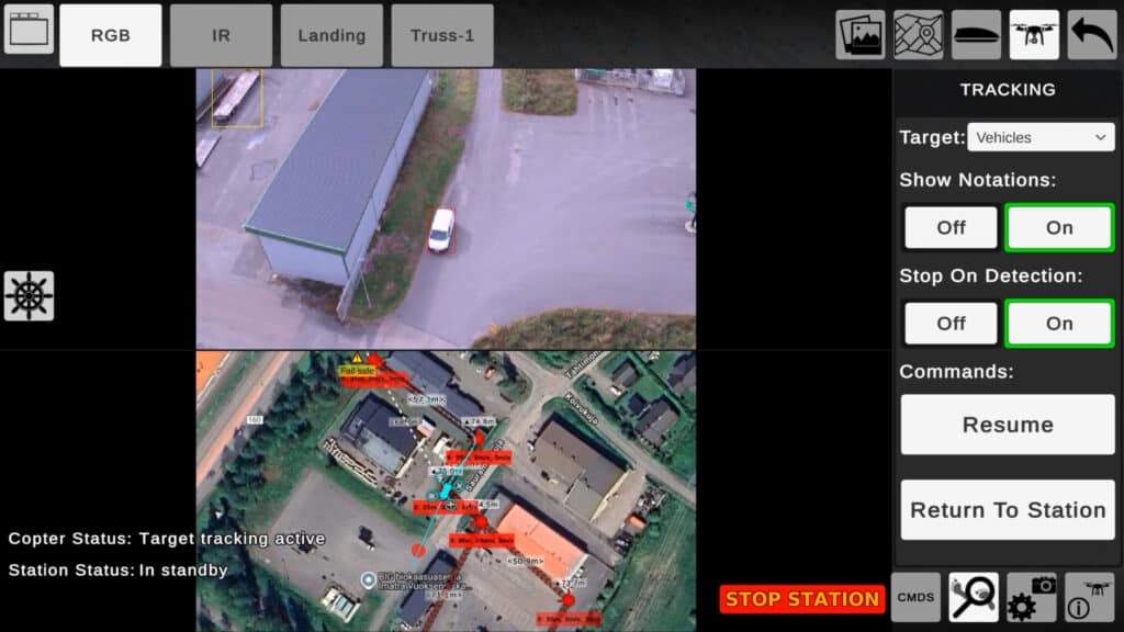
This is more than surveillance; it’s mobility intelligence. Skyfleet’s onboard AI performs vehicle tracking and flow analysis in real time, building traffic heat maps and identifying patterns across large areas. It detects abnormal behaviour—sudden braking waves, dangerous merges, near-misses at a junction—and flags them before they escalate. The result is 24/7 situational awareness that helps operators act now and plan smarter for later.
Rapid response, measurable impact
Speed matters. The longer an incident goes unmanaged, the more it costs in time, emissions, and public frustration. Skyfleet reduces incident detection times from minutes to seconds, pushing live insights to traffic management centres and field teams. Operators get a clear aerial picture—no guesswork, no second-hand reports—so they can adjust signal timings, deploy recovery vehicles, post accurate travel advice, or reroute buses and emergency services with confidence.
During planned roadworks or major events, Skyfleet scales up to maintain flow. Robocopters can patrol diversion routes, watch for rat-running through residential streets, and verify whether signage is working as intended. For winter operations, they track snowfall impacts across the network and help prioritise gritting, while in summer they monitor bank holiday surges towards coastlines and tourist hotspots. The effect is practical and immediate: fewer surprises, faster clearance, smoother journeys.
AI pattern recognition that powers smarter cities
Skyfleet is engineered for the realities of public infrastructure. Robocopters operate as a coordinated fleet with safe deconfliction, automated handovers, and resilient communications. They fly to the rules, respect no-fly areas, and maintain privacy by design; analysis focuses on traffic flow and vehicle classes, not personal identity. Data slots neatly into your existing traffic platforms via secure APIs, so your teams see Skyfleet’s insights alongside your current feeds and controls—no rip-and-replace required.
Because Skyfleet is autonomous monitoring from the ground up, coverage expands as your needs grow. Start with a corridor, scale to a city, extend to an entire region. When priorities shift—from school-run peaks to overnight freight windows—the system adapts in minutes, not months.
The future-proof layer every network needs
Congestion will not fix itself. As cities add EVs, micromobility, and connected vehicles, complexity increases and expectations rise. Operators need aerial surveillance that keeps pace, with the precision and reliability to guide every decision. Skyfleet from Rumble Tools delivers exactly that: AI robocopters that provide real-time analytics, continuous vehicle monitoring, and immediate response across vast areas. It’s how transport authorities move from reacting to leading.
Partner with Rumble Tools
If you’re planning a smart city upgrade, managing a congested corridor, or preparing for major works, now is the time to add Skyfleet’s aerial intelligence to your toolkit. Book a consultation with Rumble Tools to see live traffic heat maps, vehicle tracking feeds, and swarm monitoring in action, and design an autonomous monitoring plan tailored to your network. Let’s build faster, safer, cleaner mobility—starting today.
Read More
-
The End of Slow Patrols: Skyfleet’s Autonomous Drones Deliver Always‑On Security
Security teams are under pressure. Perimeters grow, sites sprawl, and budgets tighten. Yet the risks keep rising—trespass, theft, vandalism, safety breaches, and the knock‑on effects of downtime. Manual patrols simply can’t keep pace. They’re slow, expensive to scale, and limited…November 3, 2025